
Hunza River Flood Destroys Karakoram Highway | Pakistan-China Road Link Severed
Overview
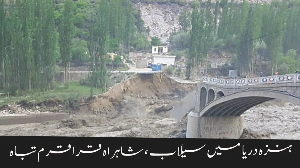
In a major setback for northern Pakistan’s connectivity, a large section of the Karakoram Highway (KKH) in Hunza’s Morkhoon area has been swept away by the rising waters of the Hunza River. This has caused a complete suspension of road traffic between Pakistan and China, severing a crucial trade and travel link.
What Happened?
- Cause: Heavy rains combined with accelerated glacier melting have led to riverbank erosion.
- Impact Area: Morkhoon and Gircha locations were hit hardest, with the road sustaining severe damage.
- Immediate Result: The section from Sost to Gulmit is now closed for all kinds of vehicles.
- Connectivity Loss: Land-based trade and travel between Pakistan and China have come to a halt.
Details of the Incident
According to local police and disaster management authorities:
- Continuous rainfall increased the Hunza River’s water level.
- Glacial melt intensified river erosion, which washed away portions of the highway.
- The upper Gojal villages have been cut off from other regions due to landslides and road collapse.
Other Affected Roads
- Gilgit–Shandur Road:
- Closed for the past 12 days at Khalti Khatam due to riverbank erosion.
- Phander and Gupis areas remain isolated.
- Food shortages and scarcity of essential supplies are causing distress among residents.
- Road restoration is challenging as entire mountain slopes need to be cut away to rebuild the road.
Government Response
- The Chief Minister of Gilgit-Baltistan has ordered speedy restoration of the Karakoram Highway.
- Emergency arrangements are being made to deliver food and medicines to affected areas via Upper Chitral routes.
- Work crews have been active for the past three days, but progress is slow due to difficult terrain.
Why Is This Happening More Often?
Experts point to climate change as the main driver:
- Glacial Melting: Rising temperatures are accelerating the melting of glaciers in the Karakoram and Himalayas.
- Heavy Rainfall: Unpredictable and intense rainfall patterns are leading to flash floods.
- Riverbank Erosion: Fast-moving water weakens soil and rock, causing infrastructure collapse.
Frequently Asked Questions (FAQs)
What is the Karakoram Highway?
The Karakoram Highway is one of the highest paved roads in the world, connecting Pakistan and China via the Khunjerab Pass. It’s a major trade route and a symbol of Pak-China friendship.
How long will repairs take?
Officials have not given an exact timeline, but given the scale of destruction and difficult mountain terrain, it could take weeks or even months.
Which areas are worst affected?
Morkhoon and Gircha (Hunza)
Upper Gojal villages
Phander and Gupis (Ghizer District)
Is there any alternative route?
Currently, the only alternative is via Upper Chitral for delivering essential goods, but it’s not a complete substitute for KKH.
Safety Tips for Residents
- Avoid traveling in mountainous regions during heavy rains.
- Keep emergency supplies ready (food, water, medicine).
- Stay updated with local disaster management alerts.
- Report landslides or road blockages to local authorities.
Conclusion
The Hunza River flood and subsequent destruction of the Karakoram Highway is not just a local tragedy—it’s a reminder of the growing threats posed by climate change in mountainous regions. With trade halted, communities isolated, and supplies running low, restoring the road is now a top priority. However, the bigger challenge remains: building climate-resilient infrastructure to withstand such disasters in the future.
Read this: Islamabad Declares 99 Housing Societies Illegal | CDA Targets Owners with Travel Ban
Read this: FBR Increases Tax on Bank Withdrawals for Non-Filers | New Property Tax Rates 2025